Welcome to Central Oregon, a haven for outdoor enthusiasts and a gateway to some of the best hiking experiences in the Pacific Northwest.
With its breathtaking landscapes and diverse terrain, this region offers a treasure trove of Central Oregon hiking trails waiting to be explored.
In this article, we’ll cover everything you need to know about places to hike in Central Oregon, hikes in Bend Oregon, Redmond, and other towns.
As big fans of Central Oregon hiking ourselves, we are excited to share our local tips with you, to help you make the most of these incredible trails.
Central Oregon Hiking Overview
Central Oregon is a special place, full of expansive landscapes, varying elevation hikes, and so much to offer. We’ll cover the best Central Oregon hikes to put on your list!
From the towering peaks of the Cascade Mountains to the sparkling alpine lakes and rugged high desert landscape, Central Oregon hiking delivers awe-inspiring vistas at every turn.
Join us as we dive into the best places to hike in Central Oregon, providing you with the ultimate guide to embark on remarkable journeys through this outdoor paradise.
Grab some snacks, lace up your boots, and get ready to create lasting memories and immerse yourself in the wonders of Central Oregon’s pristine wilderness.
Best Time of Year for Hiking in Central Oregon
Central Oregon offers a unique hiking experience throughout the year, with each season bringing its own set of advantages and considerations. Understanding the characteristics of each season will help you plan your hiking adventures accordingly.
| Season | Characteristics | Advantages | Considerations |
| Spring | – Blooming wildflowers – Mild temperatures – Less crowded trails | – Vibrant landscapes – Tranquility – Ideal for photography | – Lingering snow at higher elevations – Potential trail closures – Mosquitos |
| Summer | – Warm and sunny weather – Snow-free trails – Long daylight hours | – Access to higher elevation trails – Breathtaking alpine views – Extended hiking time | – Peak tourist season (crowded trails) – Consider early start times for parking availability |
| Fall | – Colorful foliage- Comfortable temperatures – Quieter trails | – Stunning fall colors- Tranquility – Great for photography | – Unpredictable weather conditions – Check for trail closures – Cooler temperatures later in the season |
| Winter | – Snow-covered landscapes – Serene atmosphere – Potential for solitude | – Unique snowy scenery – Snowshoeing and winter hiking – Quieter trails | – Changing weather conditions – Dress appropriately in layers – Check trail conditions for safety |
Even during winter in Bend, there are lots of winter hikes Central Oregon has to offer, including lower elevation trails.
Central Oregon Hiking Map
Expand this interactive map to see all of the hikes mentioned in this article. This isn’t a proper Central Oregon hiking trail map, but it will help you get your bearings.
Central Oregon Hiking Trails – By Region
In this section we’ll divide Central Oregon into 7 regions: all of Central Oregon, close to towns, Deschutes National Forest, Willamette National Forest, Umpqua National Forest, John Day Fossil Beds, and Crater Lake National Park. We provide the best hikes in each region.
Overall Best Central Oregon Hikes
These are some of the most popular hikes in all of Central Oregon. Note the diversity of terrain and landscapes across these hikes. Click on the link in the “Hike” column to see more information.
| Hike | Location | Short Summary |
| Ray Atkeson Memorial Trail | Deschutes National Forest, Sparks Lake | Accessible lakeside trail with mountain views. |
| Misery Ridge | Smith Rock State Park | Impressive rock formations. Steep hike that rewards with expansive views. |
| Todd Lake to No Name Lake | Deschutes National Forest, Three Sisters Wilderness | Long climb to a striking alpine lake with generous landscape views. |
| Painted Hills Overlook Trail | John Day Fossil Beds National Monument | Colorful geology on display in an area with a rich fossil record. |
| Garfield Peak Trail | Crater Lake National Park | Expansive views of Crater Lake from one of the highest points on the rim. |
| Blue Pool | Willamette National Forest | Stunning deep blue pond in a vibrant forest. |
In addition to day hikes, there are lots of backpacking Central Oregon has to offer. Check out our full article about backpacking in Central Oregon.
Hikes in and near Towns: Bend, Sisters and Redmond
One of the great things about living in and visiting central Oregon is how accessible outdoor spaces are.
Unlike larger cities, a short 10-minute drive will get you out of any Central Oregon town. Within an hour, hundreds of incredible hikes await.
However, even within town there are some great hikes. These are the top hikes near Bend, Sisters, and Redmond.
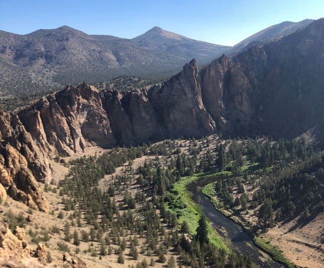
Misery Ridge – Smith Rock State Park – Redmond
Length: 3.5 miles
Elevation Gain: 950 feet
Great for: Challenging and rewarding hike with excellent views and impressive rock formations
Drawbacks: Can be crowded during peak times
Distance from Redmond: 15 minutes

Perhaps one of the most popular trails in Central Oregon, the Misery Ridge Loop is demanding and rewarding. This 3.5-mile loop has almost 1,000 feet of elevation gain and you will feel it.
At the top, you will be rewarded with incredible views of the surrounding rock formations, the high desert, and the peaks of the Cascade Mountains.
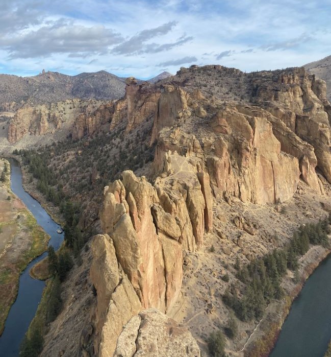
This loop can be done clockwise and counterclockwise. Another plus is that you get to see lots of rock climbers. Smith Rock is one of the most popular sport climbing destinations in the Pacific Northwest.
There are also lots of other hikes at Smith Rock State Park, though Misery Ridge should be the first on your to-do list.
Local Tip: Smith Rock is a great option for Central Oregon winter hikes.
Deschutes River Trail – Bend
Length: 3 – 5 miles
Elevation Gain: Almost none
Great for: Riverside hike close to Bend
Drawbacks: Not many expansive views
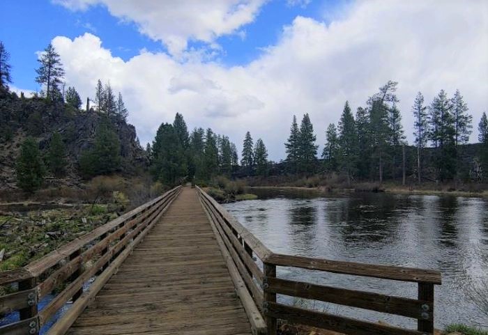
The Deschutes River Trail has many different sections, both in Bend and outside of town. This trail always follows the Deschutes River and is popular for dog walking and running in addition to a mellow stroll.
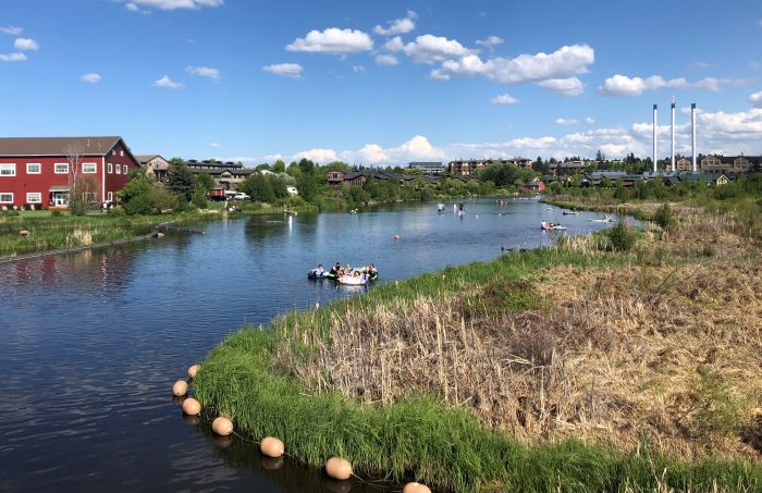
While there are not many views, this is perhaps the most popular example of accessibility to natural areas within the town of Bend. Overall, the Deschutes River Trail is one of the best Bend trails for a reason! This is another great option for winter hikes in Central Oregon.
Learn more in our full article about the Deschutes River Trail.
Tumalo Creek Loop Trail – Bend
Length: 5 miles
Elevation Gain: 300 feet
Great for: Forested, river-side hike close to Bend
Drawbacks: Not many views of landscape
Tumalo Creek Loop Trail in Shevlin Park is just outside of Bend and another great example of accessible hikes in Bend Oregon. This trail follows the pristine Tumalo Creek as it flows through a beautiful, forested area.
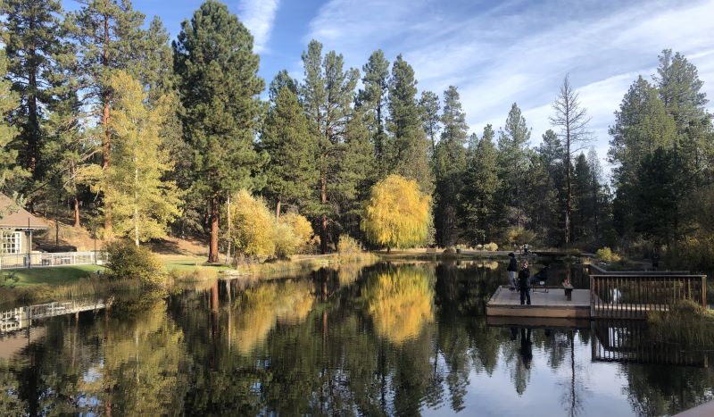
This loop and others in Shevlin Park is great for a morning or afternoon hike to get your blood flowing. Shevlin Park offers several excellent hikes near Bend. In addition, the colorful Aspen trees make this one of the best fall hikes in Central Oregon.
Learn more in our full article about Shevlin Park. For more great places to hike in Bend Oregon, check out our full article on Bend hikes.
Black Butte Trail – Sisters
Length: 4 miles
Elevation Gain: 1,500 feet
Great for: Moderate summit with excellent views
Drawbacks: Road in may be in rough shape
Black Butte Trail is a classic moderate Central Oregon summit. The road winds part way up the butte and can be rough but doable with 4 wheel drive.
Alternatively, you can start at a lower elevation and hike further. Either way, the views at the top are tremendous. Feast your eyes on all of the nearby peaks!
Best Hikes in Deschutes National Forest
Deschutes National Forest is a Central Oregon hiking paradise, spanning 1.6 million acres of diverse landscapes. With towering peaks, lush forests, and meandering rivers, it offers a wealth of hiking opportunities for all skill levels.
Let’s explore well-maintained trails that lead to stunning vistas, hidden waterfalls, and serene alpine meadows within the Deschutes National Forest.
Trails along the Cascade Lakes Scenic Byway are some of the best places to hike in Central Oregon.
Ray Atkeson Memorial Trail
Length: 2.4 miles
Elevation Gain: Minimal
Great for: Mellow yet engaging hike through lava fields and along Sparks Lake
Drawbacks: Bumpy dirt road access
Distance from Bend: 45 minutes
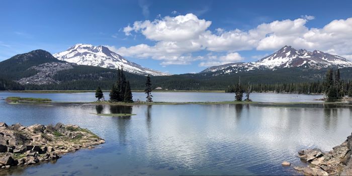
In our opinion, this is one of Central Oregon’s must do hikes. The Ray Atkeson Memorial Trail starts at the Sparks Lake Day Use Area, which requires about 5 – 10 minutes of driving on a dirt road.
If you have time, we recommend doing the entire loop counter-clockwise. This way, you can start by walking through lava flows and end with magnificent views of the lake and mountains. If you are short on time. Do just the lakeside section as it offers some of the best views in central Oregon.
Green Lakes Trail
Length: 9 miles
Elevation Gain: 1,200 feet
Great for: Rewarding climb alongside a creek with a series of lakes and views at the top
Drawbacks: None!
Distance from Bend: 1 hour
Green Lakes Trail is a pleasant but challenging 9-mile hike that climbs 1,200 feet to Green Lakes, a series of lakes sandwiched between South Sister and Broken Top, right at the tree line.
These alpine lakes provide an excellent foreground as you get up close and personal with both of these iconic Central Oregon peaks. Overall, this is a great way to spend a day.
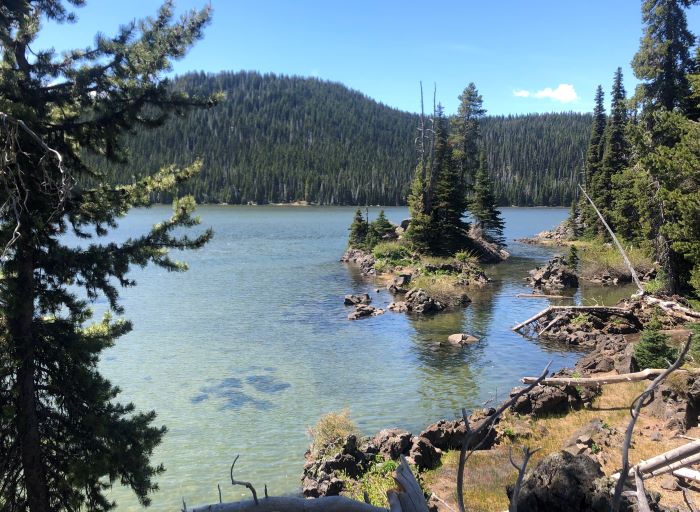
No Name Lake Trail – Broken Top Hike Bend Oregon
Length: From Todd Lake – 13.5 miles, From Three Creek Lake: 11 miles
Elevation Gain: From Todd Lake – 2,700 feet, From Three Creek Lake: 2,000 feet
Great for: Expansive views, stunning alpine lake, high exposure, challenging hike
Drawbacks: Lots of loose rock near the top, trail may be unclear
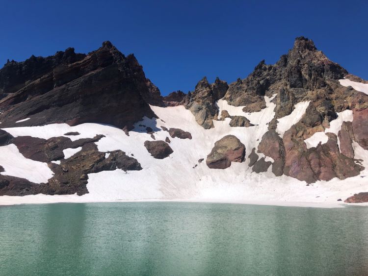
No Name Lake is one of the higher elevation lakes in Central Oregon, at about 8,000 feet. There are several ways to arrive at this lake.
The two most common are via Todd Lake Trailhead (south) and via Three Creek Lake Trailhead (east). Both ways are beautiful and showcase different scenery.
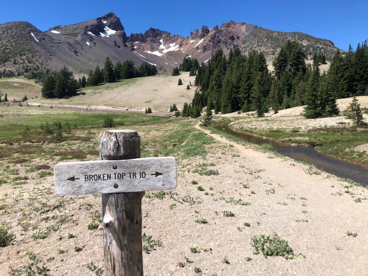
Todd Lake Trailhead is more accessible (right off the Cascade Lakes Scenic Byway), while Three Creek Lake Trailhead requires driving on a bumpy dirt road.
Set aside a day to explore this incredible hike that offers some of Central Oregon’s best mountain landscape views.
Learn more in our full guide to hiking to No Name Lake.
Hikes in Willamette National Forest
As Deschutes National Forest is on the east side of the Cascade Mountain Range, the Willamette National Forest is on the west. With much more rainfall than its drier counterpart, Willamette National Forest is lush and full of beautiful rivers, lakes, and forests.
Pamelia Lake Trail
Length: 4.5 miles
Elevation Gain: 780 feet
Great for: Lush forests, beautiful lake with mountain views
Drawbacks: Easy to lose the trail
Pamelia Lake Trail is a moderate and rewarding stride through the lush Willamette National Forest. The trail can be hard to follow at times, especially if there is snow early in the season.
However, most people can find their way to Pamelia Lake which serves as a beautiful foreground to Mount Jefferson towering above.
Blue Pool Via Mckenzie River Trail
Length: 4 miles
Elevation Gain: 350 feet
Great for: Stunning blue water and crispy clean river
Drawbacks: Popular, can be crowded
Blue Pool is a must-do hike in the Willamette National Forest. One of the most popular hikes in the area, this path follows one of the best sections of the McKenzie River Trail, a longer hike.
The main draw is Blue Pool itself which is absolutely stunning. Put this one on your to-do list and make a plan!
Scott Mountain Loop Trail
Length: 9.2 miles
Elevation Gain: 1,500 feet
Great for: Long loop with lakes and mountain views
Drawbacks: Lots of exposure in some parts
Scott Mountain Loop Trail is a long loop hike with a balanced mixture of both lakes and views. The hike is mostly forested but still gets a lot of sun in some places. This is not one of the more popular hikes in the area so there will be less crowds.
Overall, this is a great hike if you’re looking for a less trafficked hike with views. In addition, the Scott Mountain Loop Trail is also great for a one-night backpacking trip.
Little Belknap Crater
Length: 6 miles
Elevation Gain: 1,200 feet
Great for: Rugged hikes on lava flow field
Drawbacks: Extremely exposed
This moderate hike to Little Belknap Crater traverses a bizarre and rugged landscape of lava flows. The trail is very exposed with little to no shade.
For this reason, it is best done on a cool but clear day. Overall, this hike is a great way to explore the Mount Washington Wilderness. To get a better view and add on another 2 miles, hike up to Belknap Crater.
Hikes in Umpqua National Forest
Umpqua National Forest is south of Willamette NF and a lot smaller. Don’t let its size fool you. The terrain and natural beauty is beautiful and full of hikes, waterfalls, and a wonderful hot spring. These are the top hikes in Umpqua National Forest.
Highway 138 Waterfalls
Length: Variable
Elevation Gain: Minimal
Great for: Several short hikes to waterfalls right along main road
Drawbacks: Not very immersive in nature
Highway 138 slices through Umpqua National Forest and is incredibly scenic. Along the way, there are at least four waterfalls that are just off the highway and totally worth seeing.
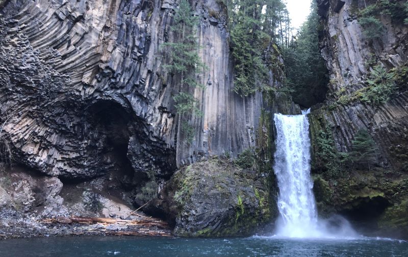
This is a great way to spend a few hours just hopping from one to the next. These spectacular waterfalls are named Clearwater, Whitehorse, Watson, and Toketee from east to west.
Mount Thielsen Trail
Length: 10 miles
Elevation Gain: 3,700 feet
Great for: Beginner alpine summit or challenging climb
Drawbacks: Steep scree field near the top
Mount Thielsen Trail is a great peak to summit as a beginner. The trail starts as a mellow and pleasant hike through the forest before rising quickly into rocky and steep terrain. Not for the faint of heart, to summit the peak requires an easy but exposed scramble.
The 360 degree views from the top are spectacular but the high exposure will get your palms sweating. It is best to rappel from the top.
Umpqua Hot Springs
Length: 1 mile
Elevation Gain: 300 feet
Great for: Natural hot spring soaking!
Drawbacks: Can get crowded and rowdy
One of the most popular hot springs in Oregon, we couldn’t leave off Umpqua Hot Springs. This natural hot spring is the source of a series of pools cascading down a hillside above the North Umpqua River. The atmosphere, when not full of partiers, is serene.

Get here on a weekday, especially late at night or early in the morning for the best chance at a mellow soak. In the winter, you have to hike a lot further due to road closure, but that also decreases crowds.
Hikes in John Day Fossil Beds National Monument
Nestled in Central Oregon, the John Day Fossil Beds National Monument beckons with its extraordinary fossil treasure trove and captivating geological formations. This monument is composed of three distinct units: the Painted Hills Unit, the Sheep Rock Unit, and the Clarno Unit.
The John Day Fossil Beds National Monument preserves a remarkable tapestry of primordial life with one of the best-preserved fossil records in the U.S. Yet, visitors are also invited to savor the allure of Central Oregon’s geological wonders.
Check out the John Day Fossil Beds National Monument hikes below and don’t forget to stop by the Thomas Condon Paleontology Center to learn more about the rich history of this area.
Learn more in our full article about the John Day Fossil Beds National Monument.
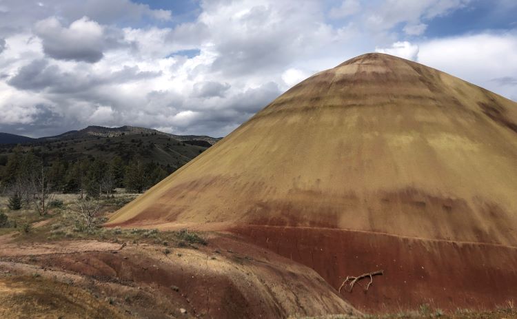
Painted Hills Overlook Trail
Length: 0.5 miles
Elevation Gain: Minimal
Great for: Most popular hike in the Painted Hills
Drawbacks: It’s so short!
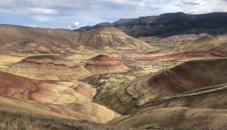
The Painted Hills Overlook Trail is the main draw of the Painted Hills unit. This short trail showcases the unique landscape that makes the Painted Hills so popular. The bizarre mounds of dirt display colorful ribbons of history right before your eyes!
There are probably 4 or 5 short hikes in the Painted Hills Unit worth doing. In this article we mention our two favorites. If you are headed to Painted Hills, make sure you do some more research about the area and plan out a day to do all the hikes.
Painted Cove Trail
Length: < 0.5 miles
Elevation Gain: None
Great for: Short hike in Painted Hills as part of a longer day
Drawbacks: It’s so short!
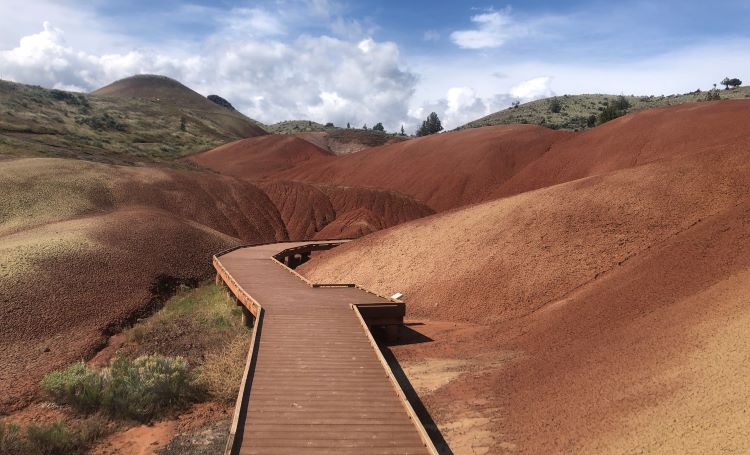
Painted Cove Trail has to be one of the most unique places in Oregon. This short but vibrant loop features the most bizarre dirt piles you’ve ever seen. The bright hues of the earth are something to marvel at.
Blue Basin Overlook Trail
Length: 4 miles
Elevation Gain: 1,000 feet
Great for: Unique geology and colorful landscape views
Drawbacks: Minimal shade, sometimes muddy
Blue Basin Overlook Trail circles around Blue Basin and is about 4 miles long and takes less than 2 hours to complete. Starting the trail with Islands in Time (a short hike within the Blue Basin) is recommended and adds distance.
Blue Basin is a unique geological phenomenon where the rock is a calming turquoise green-blue color. We recommend visiting in the spring, when there is a small stream that takes on the same color as the rock!
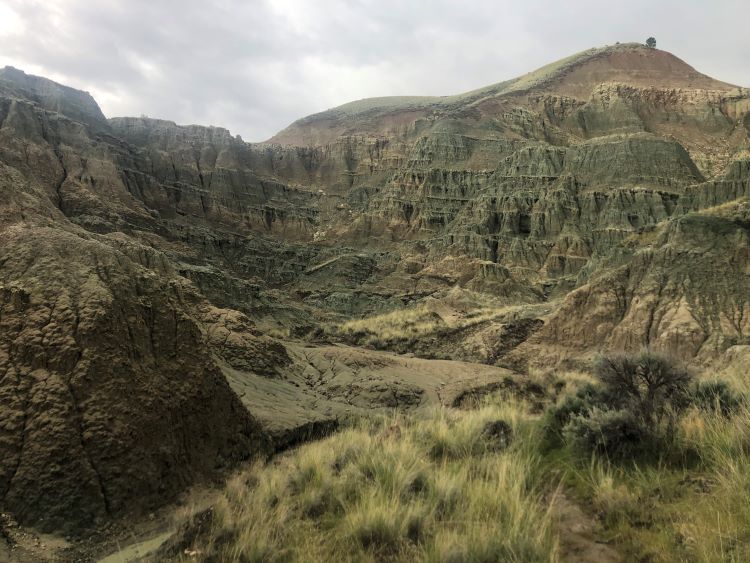
The trail is well-maintained and offers beautiful vistas, but can be steep in parts. Be sure to bring water, sunscreen, and appropriate footwear. Overall, hikers enjoy the stunning scenery, unique geology, and peacefulness of the trail.
Hikes in Crater Lake National Park
A hiking guide to Central Oregon wouldn’t be complete without including Crater Lake National Park. Oregon’s only national park, Crater Lake has developed a strong reputation for unique and stunning views.
Garfield Peak Trail
Length: 3.5 miles
Elevation Gain: 1,000 feet
Great for: Expansive views of the lake from one of the highest points on the rim
Drawbacks: Minimal shade and high exposure
Garfield Peak Trail starts at the Rim Village Visitors Center and climbs 1,000 feet over 1.75 miles. While the trail is steep and rocky at times, hikers are rewarded with excellent views of one of Oregon’s wonders. This is perhaps the most popular hike on the Crater Lake Rim.
Wizard Island Trail
Length: 2.5 miles
Elevation Gain: 760 feet
Great for: Unique hike on an island in Crater Lake!
Drawbacks: Requires boat ride to access
Wizard Island Trail is one of the more unique hikes in Oregon. It requires a short boat ride to access the island.
Once at the island, you hike up a rocky slope to the top and are presented with expansive views of the lake along the way. Overall, this trail is worthwhile if you want a full Crater Lake experience.
Conclusion
We hope you found this guide to Central Oregon hiking helpful. While this list is a good start, the reality is that there are so many excellent hikes in Central Oregon. We have just begun to scratch the surface here. Have fun exploring!
You might also be interested in our other article about day hikes near Bend and backpacking trails near Bend. Central Oregon backpacking trails offer immersive multi-day hikes.
If you are visiting Central Oregon, welcome! We hope you enjoy your time here. If you’re still in the planning stages, be sure to check out our other articles about visiting central Oregon. You also might want to know some other things to do in Bend. Let us help plan your trip with insightful Bend trip itineraries.
")
")
")
")
")
")